


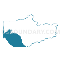
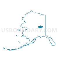
Ester Precinct, Fairbanks North Star Borough, Alaska
About
Outline

Summary
| Unique Area Identifier | 523352 |
| Name | Ester Precinct |
| County | Fairbanks North Star Borough |
| State | Alaska |
| Area (square miles) | 1,417.57 |
| Land Area (square miles) | 1,390.32 |
| Water Area (square miles) | 27.25 |
| % of Land Area | 98.08 |
| % of Water Area | 1.92 |
| Latitude of the Internal Point | 64.52582940 |
| Longtitude of the Internal Point | -147.98154580 |
Maps

Graphs
Select a template below for downloading or customizing gragh for Ester Precinct, Fairbanks North Star Borough, Alaska


Neighbors
Neighoring Voting District (by Name) Neighboring Voting District on the Map
- Big Delta Precinct, Southeast Fairbanks Census Area, AK
- Chena Precinct, Fairbanks North Star Borough, AK
- Clear Precinct (Part; Also See Part In Denali Borough), Yukon-Koyukuk Census Area, AK
- Clear Precinct (Part; Also See Part In Yukon-Koyukuk Census Area), Denali Borough, AK
- Eielson Precinct, Fairbanks North Star Borough, AK
- Fort Wainwright Precinct, Fairbanks North Star Borough, AK
- Goldstream No. 2 Precinct, Fairbanks North Star Borough, AK
- Lakeview Precinct, Fairbanks North Star Borough, AK
- Manley Hot Springs Precinct, Yukon-Koyukuk Census Area, AK
- Moose Creek Precinct, Fairbanks North Star Borough, AK
- Nenana Precinct, Yukon-Koyukuk Census Area, AK
- Pike Precinct, Fairbanks North Star Borough, AK
- Richardson Precinct, Fairbanks North Star Borough, AK
- Salcha Precinct, Fairbanks North Star Borough, AK
- University Hills Precinct, Fairbanks North Star Borough, AK
Top 10 Neighboring County Subdivision (by Population) Neighboring County Subdivision on the Map
- Fairbanks North Star census subarea, Fairbanks North Star Borough, AK (97,581)
- Southeast Fairbanks census subarea, Southeast Fairbanks Census Area, AK (7,029)
- Koyukuk-Middle Yukon census subarea, Yukon-Koyukuk Census Area, AK (3,219)
- Denali census subarea, Denali Borough, AK (1,826)
Top 10 Neighboring Place (by Population) Neighboring Place on the Map
- Fairbanks city, AK (31,535)
- Badger CDP, AK (19,482)
- Chena Ridge CDP, AK (5,791)
- Goldstream CDP, AK (3,557)
- Ester CDP, AK (2,422)
- Salcha CDP, AK (1,095)
- South Van Horn CDP, AK (558)
- Harding-Birch Lakes CDP, AK (299)
Top 10 Neighboring Unified School District (by Population) Neighboring Unified School District on the Map
- Fairbanks North Star Borough School District, AK (97,581)
- Delta/Greely School District, AK (4,810)
- Yukon-Koyukuk School District, AK (1,996)
- Denali Borough School District, AK (1,826)
Top 10 Neighboring State Legislative District Lower Chamber (by Population) Neighboring State Legislative District Lower Chamber on the Map
- State House District 11, North Pole, AK (21,692)
- State House District 8, Denali-University, AK (19,960)
- State House District 10, Fairbanks-Fort Wainwright, AK (16,548)
- State House District 12, Richardson-Glenn Highways, AK (14,811)
- State House District 6, Interior Villages, AK (14,235)
Top 10 Neighboring State Legislative District Upper Chamber (by Population) Neighboring State Legislative District Upper Chamber on the Map
- State Senate District D, AK (40,942)
- State Senate District F, AK (36,503)
- State Senate District E, AK (32,697)
- State Senate District C, AK (28,081)
Top 10 Neighboring 111th Congressional District (by Population) Neighboring 111th Congressional District on the Map
Top 10 Neighboring Census Tract (by Population) Neighboring Census Tract on the Map
- Census Tract 19, Fairbanks North Star Borough, AK (11,684)
- Census Tract 11, Fairbanks North Star Borough, AK (8,143)
- Census Tract 14, Fairbanks North Star Borough, AK (7,357)
- Census Tract 9, Fairbanks North Star Borough, AK (5,772)
- Census Tract 4, Southeast Fairbanks Census Area, AK (4,810)
- Census Tract 18, Fairbanks North Star Borough, AK (2,743)
- Census Tract 1, Denali Borough, AK (1,826)
- Census Tract 10, Fairbanks North Star Borough, AK (1,529)
- Census Tract 2, Yukon-Koyukuk Census Area, AK (1,461)
- Census Tract 17, Fairbanks North Star Borough, AK (1,422)